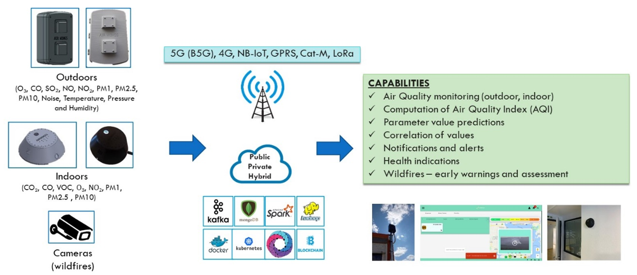
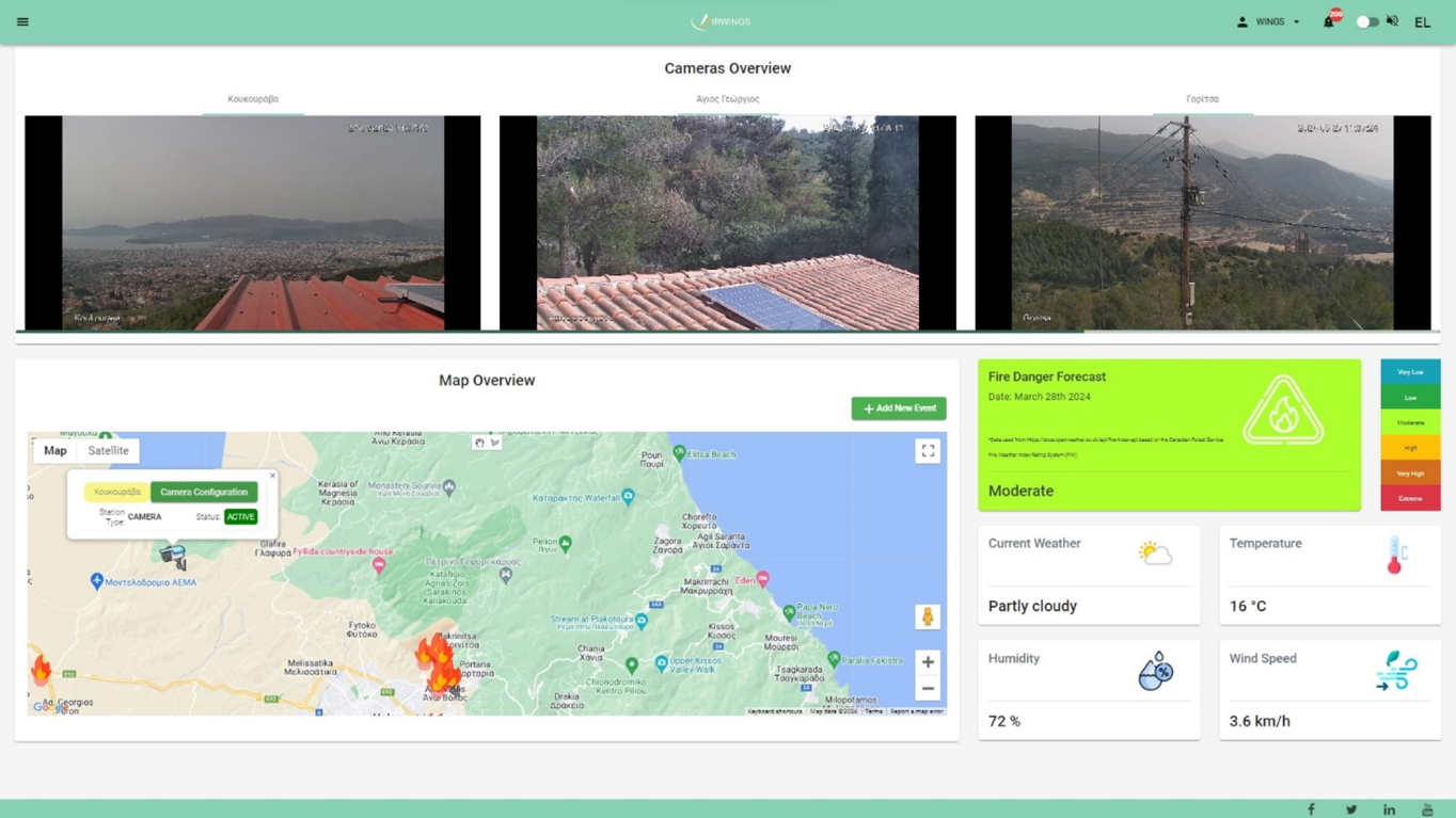
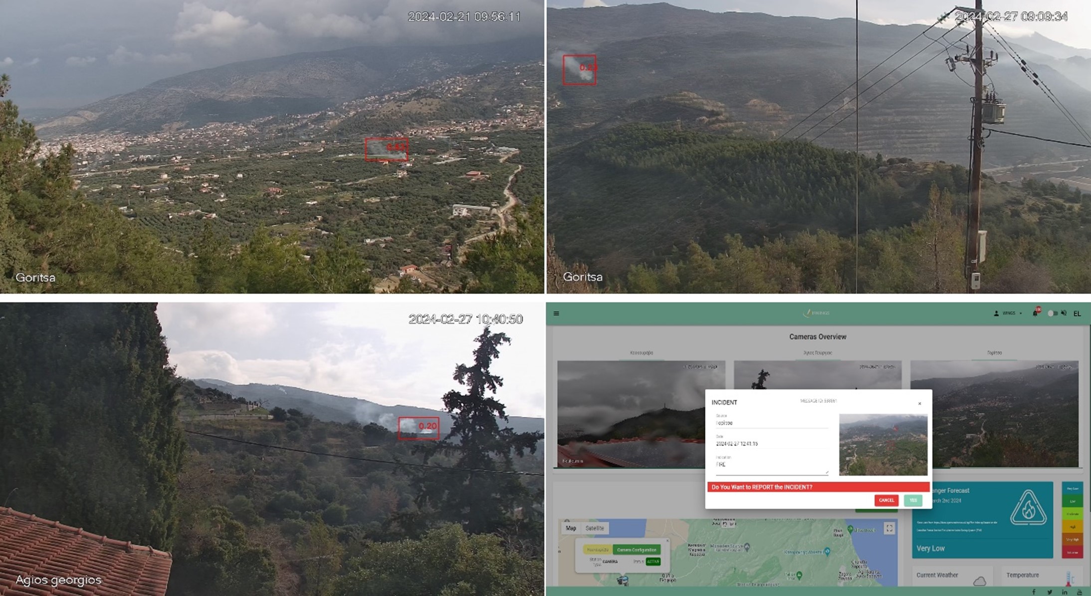
loading
hello dummmy text
koncpt-img

AIRWINGSplus is a comprehensive and patented technology solution, which combines Internet of Things (IoT), cellular connectivity and Artificial Intelligence (AI) for the live monitoring, measurement, and management of wildfires.

AIRWINGSplus enables you to:

Get early warnings, alerts and assessment for wildfires

Detect an anomaly (e.g., smoke or abnormal temperature) within 10km range of each IoT sensor

Monitor urban forests in real-time through hybrid cameras (thermal and optical)

Track live ambient factors such as air quality, particulates, and environmental variables

Predict the possibility of a future fire

The AIRWINGSplus wildfire prevention system provides public service and civil protection officials a sophisticated solution for safeguarding communities and natural resources from wildfires.
Product Description

The AIRWINGSplus solution offers an integrated system of advanced hardware and software technologies for wildfire prevention and early detection needs. AIRWINGSPlus ensures the 24/7 surveillance of the selected areas. It provides early detection of fires automatically and without requiring human intervention. Fire is detected within the first 3 minutes upon the initial emergence of smoke at the site.

AIRWINGSPlus consists of:

– Cameras (hybrid, optical-thermal for 24/7 surveillance)

– Multi-sensor stations (AIRWINGSPlus devices) for environmental and meteorological monitoring

– Transmission devices for communications over 4G/5G/NB-IoT networks

– Cloud management platform (AIRWINGSPlus platform), which includes all software for early fire detection and alerting

– Artificial Intelligence algorithms for predicting the degree of risk, detecting incidents and predicting the evolution of fires

AIRWINGSplus Devices

AIRWINGSplus devices can sense the following parameters: (a) Gases: O3, CO, CO₂, SO₂, NO, NO2; (b) Particulates: PM1, PM2.5, PM10; (c) Other: Noise, Pressure, Temperature, Humidity. Additional extensions can be provided to measure other weather aspects such as wind, precipitation, and solar radiation.

High-level illustration of the AIRWINGSplus for early detection of air quality levels and of wildfires.

Cameras

Type

– Hybrid

– Thermal and Visible

PTZ

– Pan: 0° to 360° endless

Heat Detection

– Heat Detection Distance: 3km – 5km

AIRWINGSPlus platform

– Device – equipment management

– Information visualization (sensor data, images, videos)

– AI for predicting the degree of risk / wildfire danger

– AI for wildfire detection (sending warnings and alerts)

– Smart techniques for predicting the evolution of wildfires

– Interconnection with third party systems (civil protection, fire brigade, municipality, region)

AI Training Methodology

– Deep Neural Network Architecture

– Model training from real fire simulations

– Model operation under general and different conditions, lighting, shading and topographic features (cities, forests, parks)

– Model development based on a set of hundreds of thousands of images

– Utilization of artificial images resulting from augmentation techniques

– Model training to calculate the location of the potential source (fire, smoke), its size and the degree of confidence characterizing the specific location

Product Dashboard

Installations

AIRWINGSplus autonomous fire detection through AI and video analytics deployed in Central Greece. Cameras are used to monitor distinct areas. Detection of smoke alerts the operator to investigate the issue and prompts the person to report the incident in case of fire.

Request a Demo:

To request a demo of AIRWINGSplus, please submit the form below.

By using this form, you comply with terms and conditions of the WINGS ICT Solutions P.C. with respect to the collection and use of your personal data. Please find the terms of our privacy policy here.

espa banners square